
Ruins may identify castle linked to Myriokephalon battle
A ruined settlement overlooking Turkey’s Kufi Valley may be the castle associated with the Battle of Myriokephalon in 1176. Hasan Kara and İbrahim Balık of Pamukkale University proposed the identification in a study published in the Journal of Anatolian Cultural Research in December 2024.
- Researchers propose that ruins near Çivril in western Turkey belong to the castle that gave Myriokephalon its name.
- Their identification combines surface remains with the landscape described by Byzantine historian Niketas Choniates.
- - The proposal could help reconstruct the army’s route, but the battlefield’s precise location remains disputed.
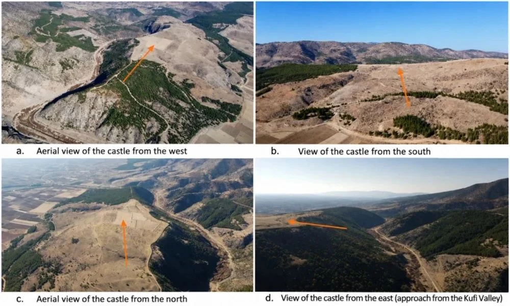
The researchers have investigated possible locations around Çivril since 2010, comparing historical accounts with the terrain. Their proposed site occupies high ground where the Kufi Valley opens onto the Çivril Plain. Recorded remains include defensive walls, towers, building foundations and possible cisterns. Drone imagery and ground surveys helped document the settlement, whose commanding position is central to their argument.
The principal historical guide is the Byzantine writer Niketas Choniates. His account describes Emperor Manuel I Komnenos passing an old, abandoned fortress called Myriokephalon before entering a narrow passage. Kara and Balık argue that the ruins and nearby valley correspond to this sequence. Surface pottery reportedly ranges from the fourth century BCE to the sixth century CE, suggesting a settlement with origins long before the battle. Its apparent antiquity is consistent with the description of a ruined landmark, although the absence of later surface finds cannot establish exactly when or why it was abandoned.
The battle took place on 17 September 1176, during Manuel’s campaign against the Sultanate of Rum, ruled by Kilij Arslan II. Seljuk forces attacked the Byzantine army in constricted terrain, inflicting heavy losses and forcing the emperor to abandon his advance. The defeat was a major setback for Byzantine attempts to recover the Anatolian interior. Locating the fortress mentioned in the campaign narrative could therefore provide an important geographical reference for understanding the army’s movements.
You Might Also Like

Identifying that landmark would not, by itself, establish the full extent of the battlefield. The proposal rests on the relationship between historical descriptions, topography and surviving surface remains, while modern disturbance and the removal of building material complicate investigation. Further archaeological work is needed to refine the settlement’s chronology and test its connection with the campaign. Securely dated military objects could strengthen the case, but the proposed identification should not yet be treated as a resolution of the long-running debate.